
The UK has a walking culture unlike anywhere else in the world. Sport England counts 19.7 million adults in England alone who walk for leisure, and National Trails across Britain collectively see 83 million visits a year, with over 80,000 people completing a full long-distance trail annually according to OurSportingLife. What makes this possible is the right-of-way network: thousands of miles of legally protected public footpaths, bridleways, and open access land that criss-cross farms, estates, and moorland. You can walk from coast to coast across England on public rights of way without needing permission from a single landowner. That's rare, and it's worth appreciating.
This guide covers the regions and trails that deliver the best walking in Britain, along with some practical detail on seasons, kit, and what to expect.
Lake District: the centre of English Walking
The Lake District is England's most visited national park. In 2024 it drew 17.73 million tourists according to the Lake District National Park Authority, which maintains 2,223 kilometres of footpaths across the park. That number tells you both how good it is and why timing matters if you want solitude.
The Lakeland Fells range from gentle valley walks to serious ridge scrambles. Scafell Pike, at 978 metres, is England's highest mountain and sees thousands of walkers each year. The route from Wasdale Head is direct but unrelenting. The longer approach from Borrowdale through Esk Hause is better walking, with more interesting terrain.
Striding Edge on Helvellyn is the Lake District's most famous scramble, a narrow rocky arête that connects the approach ridge to the summit plateau. It's exposed but well within reach of anyone comfortable on rough ground. The descent via Swirral Edge completes a satisfying horseshoe.
The central fells around Langdale and Coniston are busy in summer. The quieter northern fells, particularly around Blencathra and the Back o' Skiddaw area, offer comparable walking with a fraction of the foot traffic.
Scottish Highlands: Scale and Solitude
Scotland operates under different access laws from the rest of the UK. The Land Reform (Scotland) Act 2003 gives everyone the right to access most land and inland water for recreational purposes, provided they act responsibly. In practice this means you can walk almost anywhere in the Highlands without following designated paths, which opens up a completely different kind of trip.

Ben Nevis at 1,345 metres is the highest point in the British Isles. The tourist path from Glen Nevis is straightforward if busy. The Carn Mor Dearg Arete approach is longer and involves genuine ridge walking with exposure, but it's a far better day out.
The Cairngorms National Park is the largest in the UK and contains five of the six highest mountains in Britain. The Lairig Ghru, a 27-mile through-walk connecting Braemar and Aviemore via a high mountain pass, is one of Scotland's finest long day walks or short backpacking routes. The plateau above 1,000 metres is genuinely arctic in character and can be hit by serious weather at any time of year.
The Torridon hills in the northwest are older than almost anything on earth, Lewisian gneiss and Torridonian sandstone, and the ridge walking here is technically straightforward but feels genuinely wild. Beinn Alligin, Liathach, and Beinn Eighe each offer full-day routes with serious commitment required once you're on the ridge.
Snowdonia: Wales on Its Own Terms
Snowdon itself is crowded. On a summer weekend the Pyg Track and Miners' Track feel like queues rather than mountain routes. The Snowdon Horseshoe, taking in the Crib Goch ridge, is different: a proper mountain route with narrow, exposed sections that require confident movement on rock. It demands care and a head for heights.
The rest of the Snowdonia National Park is far less visited than the Snowdon massif. The Rhinogs, a rough chain of hills above the Mawddach Estuary, are probably the least-trodden range in Wales. Pathless moorland, heather, and old packhorse routes make for slow, satisfying navigation. The Carneddau plateau in the north of the park is the largest area of high ground above 900 metres in England and Wales outside of Scotland, and most days you'll have it to yourself.
Peak District: England's First National Park
The Peak District was the first national park designated in England, in 1951, and it remains the most accessible for the largest number of people given its position between Manchester, Sheffield, and Nottingham. The gritstone edges of the eastern Dark Peak offer some of Britain's finest edge walking: Stanage, Curbar, Froggatt, Derwent, all linked by the eastern moors. The views west across the Hope Valley are clean and long on a clear day.

Photo by Olga Lioncat via Pexels
The White Peak in the south is limestone country with dales cut by rivers. Dove Dale, Lathkill Dale, and Monsal Dale each offer pleasant valley walking with easy access. The Monsal Trail runs 8.5 miles along a former railway line through the valleys.
Kinder Scout at 636 metres is the highest point and the site of the 1932 Mass Trespass that directly led to public access legislation. The plateau is peat bog and requires navigation skills in poor visibility. The Pennine Way starts here at Edale and heads north all the way to Kirk Yetholm in Scotland.
Brecon Beacons and the South West Coast Path
The Brecon Beacons in Wales offer a different character from Snowdonia: broad whale-backed ridges rather than jagged peaks, with big sky views across to the Black Mountains to the east. Pen y Fan at 886 metres is the highest point and sees heavy traffic from the Pont ar Daf car park. The northern ridge route from Brecon is longer and quieter.
The South West Coast Path runs 630 miles around the peninsula from Minehead in Somerset to Poole Harbour in Dorset, taking in Devon and Cornwall. It passes through some of the finest cliff scenery in Britain, ancient fishing villages, and stretches of heritage coastline. Most people walk it in sections over multiple years rather than end-to-end, and almost any stretch between villages makes a satisfying day out. The sections around the Lizard in Cornwall and Hartland Quay in Devon are particularly dramatic.
Long-Distance Trails: The Pennine Way and Offa's Dyke
The Pennine Way, opened in 1965, was Britain's first long-distance footpath. It runs 268 miles from Edale in Derbyshire to Kirk Yetholm in Scotland, following the spine of northern England across moorland, limestone, and high peat. It's demanding and often boggy, particularly on the Kinder and Bleaklow sections. Most people take 16 to 19 days. Accommodation is sparse in places and requires planning.
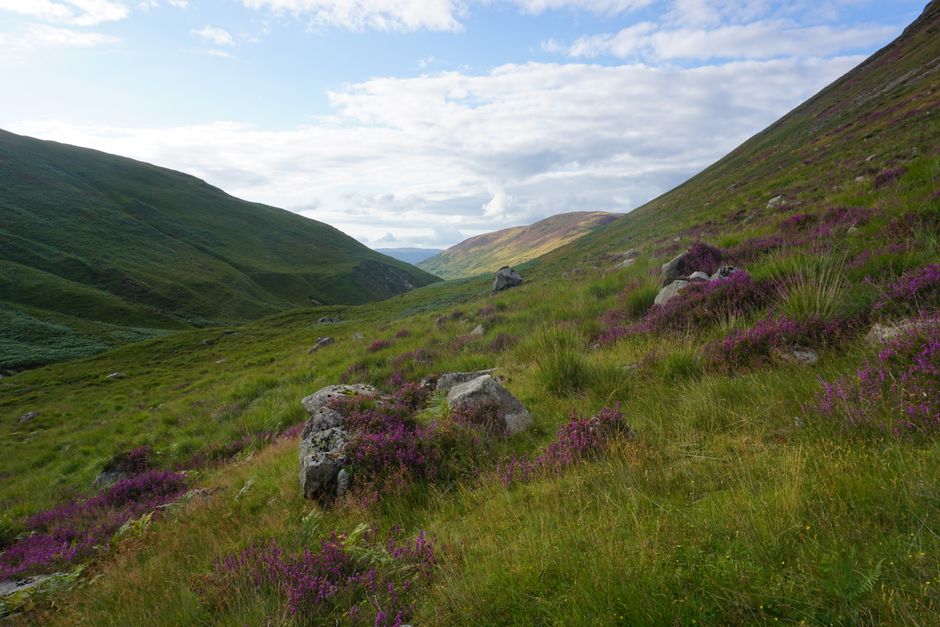
Photo by Spencer Haynes via Pexels
Offa's Dyke Path runs 177 miles along the ancient earthwork that marks the England-Wales border. The northern section through the Clwydian Range and southern section through the Black Mountains are the strongest walking. The central section across farmland is pleasant but less dramatic.
The West Highland Way in Scotland, 96 miles from Milngavie to Fort William, is probably Britain's most popular long-distance route. It's well-waymarked, well-served by accommodation, and builds in scale from lowland forest to the Rannoch Moor and the final approach to Nevis. Most walkers take seven days.
Kit for UK Walking
The UK's variable weather is the main planning challenge. It can be warm and sunny at sea level and genuinely cold, wet, and windy on any summit above 600 metres. A waterproof shell is non-negotiable for any hill day. Merino or synthetic midlayers are standard for anything above treeline. But for the long valley days, the coastal paths, and the gentler moorland routes, comfortable clothing that moves well matters more than technical performance.
The Peak Junkie Hoodie in 9oz premium fleece is a solid midlayer for cooler days on lower routes, and the Born of the North Hoodie works well for the same purpose in northern conditions. For warmer days, a well-made cotton tee like the Embrace The Mountain Call Tee (6.1oz premium) handles a full day's walking without fuss. The Captain Puffin Hiker T-Shirt is another popular option, with hand-drawn artwork by artist Maria that feels at home anywhere from the Lakeland fells to the South West Coast Path.
Boots matter significantly more in the UK than in drier mountain ranges. Even in summer, the high fells and moors are frequently waterlogged. Waterproof walking boots are standard for any route above the valley floor. For coastal and lowland trails, trail runners with aggressive tread work well.
The full Origin Collection has pieces that carry the same practical ethos as the walking culture here: straightforward, well-made, no unnecessary features.
Frequently Asked Questions
Do I need permission to walk on farmland in the UK?
In England and Wales you have a legal right to walk on public footpaths and bridleways, which are marked on Ordnance Survey maps and signposted with yellow (footpath) or blue (bridleway) arrows. You do not have a general right to walk across fields outside these paths unless they are designated open access land. Scotland operates differently under the Land Reform (Scotland) Act 2003, which gives a much broader right of responsible access across most land.
What is the best season for hiking in the UK?
May, June, and September offer the best combination of good weather and manageable crowds. July and August are warmer but busier at popular locations. March to May can offer exceptional clarity on clear days but expect unsettled weather. Winter hillwalking in Scotland requires full mountaineering competence and equipment. The UK's weather is genuinely unpredictable at any time of year, so always carry waterproofs and a warm layer regardless of the forecast.
How difficult is Striding Edge on Helvellyn?
Striding Edge is a Grade 1 scramble, meaning it requires use of hands in places and has exposed sections with significant drops on either side. It's not a technical climb but it does require confidence on rough, narrow terrain. In winter conditions with ice it becomes a serious mountaineering proposition requiring crampons and an ice axe. In dry summer conditions, most experienced walkers handle it comfortably.
How long does it take to walk the West Highland Way?
Most people complete the 96-mile route in six to eight days. The typical approach is seven days, walking roughly 12 to 15 miles per day. The terrain varies from easy lochside paths in the south to rougher moorland and mountain paths further north. The route is well-waymarked and accommodation options including bunkhouses and hotels are available at regular intervals.
Do I need an Ordnance Survey map?
For any route in the hills or on moorland, yes. The OS 1:25,000 Explorer maps show field boundaries, rights of way, and topographic detail that GPS tracks on a phone screen do not convey adequately. Carry the map and know how to use it. A phone GPS app like OS Maps or ViewRanger as a backup is sensible, but not a replacement for the paper map and the ability to read it.


