
Urban Trails: Finding Nature in the City
Most cities have more trail access than the people who live in them realise. The problem isn't usually a shortage of green space. It's that urban trails are under-documented, scattered across multiple parks departments and advocacy organisations, and require some actual searching to find. Once you've done that work for your city, you have a daily resource that most of your neighbours don't know about.
This guide is for people who want trail time as part of regular life, not just on weekends with a three-hour drive attached. It covers how to find what your city actually has, which cities have genuinely good urban trail networks, and how to dress for a trail that deposits you at a coffee shop afterwards.
What "Urban Trail" Actually Means
The term covers a wide range, and the distinction matters for how you use them. At one end: paved multi-use paths alongside rivers or through parks. These are pleasant and good for running, cycling, and pushing prams, but they're not trails in any meaningful outdoor sense. At the other end: genuine singletrack through urban forest preserves, with root systems, elevation change, and enough tree cover that you can go five minutes without seeing a building.
Both have value. The paved greenway gets you outside every day without requiring trail shoes or navigation. The singletrack through the forest preserve gives you something closer to a backcountry experience without leaving the city boundary. Most urban hikers want both, depending on the day.
Rail trails fall in between. These are former railway corridors converted to multi-use paths, and they're one of the great under-appreciated pieces of outdoor infrastructure in North America and Europe. They're generally flat, well-maintained, and surprisingly long, often connecting suburbs to city centres or linking multiple parks through corridors that would otherwise be impractical to travel on foot. The Rail-to-Trails Conservancy in the US maintains a database of more than 35,000 miles of completed rail trails, with more converting each year.
How to Find What Your City Has
Start with AllTrails. It's imperfect but comprehensive, and the user-generated reviews and photos give you a realistic picture of trail quality and current conditions. Filter by "near me" and look specifically for trails tagged as urban or city park.

The city parks and recreation department website is the second stop. These pages often list trail networks that don't appear on hiking apps because they were built and maintained as local parks infrastructure rather than recreation destinations. Some of the best urban trails are in places that were never intended as hiking destinations.
Local trail running clubs are the best human resource. The people who run trails in your city five days a week know every kilometre of maintained path, every seasonal closure, and every unofficial connector that links trails into longer routes. Most clubs have public social media pages or active Strava groups. One message to a local club will get you better information than hours of searching.
The Transit Trails concept, developed in several cities, specifically maps trails accessible by public transport. If you don't own a car, or if you want to avoid driving to a trailhead, these maps identify which trails you can reach by bus or train, with notes on exit points and return routes. Portland, Seattle, and several European cities have particularly good transit-to-trail coverage.
Cities with Genuinely Good Urban Trail Networks
Portland, Oregon has an exceptional network of Forest Park trails within the city limits. Forest Park is over 5,100 acres of temperate rainforest with more than 80 kilometres of maintained trails, including the Wildwood Trail which runs the length of the park. It's accessible by bus from the city centre and genuinely feels like wilderness hiking despite being inside a major city.
Minneapolis has the Grand Rounds National Scenic Byway, a connected trail network that circles the city and links 22 lakes and parks through 97 kilometres of paths. In winter, sections are groomed for cross-country skiing. The off-road portions through the creek and river corridors are genuine natural terrain rather than paved paths.
Sydney, Australia has the Spit Bridge to Manly coastal walk, the Blue Mountains accessible by train, and extensive harbour foreshore trails, all within the metro area. The sandstone geology creates varied terrain that surprises people who expect flat suburban walking paths.
London's urban trail network is underrated. The Capital Ring (well-signposted, 126km) and the London Loop (242km, circumnavigating the city through genuine countryside) are both largely accessible by tube and train. The Lee Valley Regional Park and Richmond Park both offer real wildlife encounters within Zone 2 and 3 tube zones.
Auckland's Waitakere Ranges, accessible by bus from the city, offer rainforest trails with kauri trees. The Hunua Ranges to the south are less visited and have more technical terrain. The regional council trail network within the city itself connects most of the volcanic cones by walking and cycling paths.
The Mental Health Case for Daily Trail Time
The research on this is consistent enough to be useful: spending time in natural environments reduces cortisol levels, lowers heart rate, and improves mood and cognitive performance measurably compared to urban walking on streets. A 2025 meta-analysis published in the American Journal of Preventive Medicine found that people living within less than a mile of newly built urban trails gained an average of 45 minutes more exercise per week after the trails were constructed, with measurable benefits still present for those living up to 2.5 miles away. The studies use a range of environments, from city parks to coastal paths to forest, and the effect holds across different ages, backgrounds, and starting fitness levels.
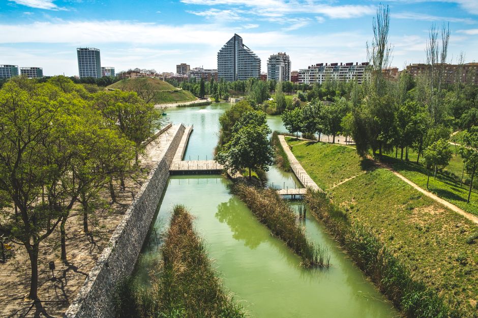
Photo by Jo Kassis via Pexels
What matters for most people is making it a daily habit rather than a weekend event. A 30-minute trail walk before or after work, on a route you know well enough to do without much planning, compounds in a way that occasional long hikes don't. The logistics friction matters: if getting to the trail takes 30 minutes each way, it won't happen on a Tuesday morning. If the trail is a ten-minute walk from your front door, it will. Health impact modelling by American Trails estimates that urban trail infrastructure prevents 95 premature deaths and saves over $1 million in treatment costs per 100,000 trail users, which puts the daily walk in a different frame than "exercise."
This is the real case for urban trail knowledge. It's not about settling for a lesser version of the mountains. It's about building daily access to the environment that actually supports how your brain and body work.
What to Wear When the Trail Ends at a Coffee Shop
Urban trail use has a clothing problem that backcountry hiking doesn't have. You need to be comfortable moving through varied terrain, managing sweat, and protecting yourself from sun and weather. You also need to look like a person when you walk into a cafe, commute to work, or meet someone for lunch after.
Technical outdoor clothing solves the trail requirements but fails the social ones. Bright-coloured synthetic trail running gear works brilliantly from a performance standpoint and announces itself conspicuously in every non-outdoor context. For urban hiking, the sweet spot is clothing that performs well enough outdoors without broadcasting that it's sportswear.
The AukCliff Simple T-shirt in the Comfort Colors 1717 heavyweight garment-dyed cotton sits in this space. It's relaxed enough to hike in comfortably, doesn't cling when you sweat, and looks like a normal t-shirt when you're at a table after the walk. The garment-dyeing process gives the fabric a worn-in softness from the first wear rather than the stiffness of new fabric. It gets better with repeated washing in a way that technical synthetic shirts don't.
For warmer days with more sun exposure, the Coastal Waves T-shirt in the same fabric does the same job with a graphic that references coastal environments. The hand-drawn artwork by artist Maria is specific enough to mean something and understated enough to work in most contexts. It reads as outdoor-interested rather than athletic-performance, which is the right register for urban trail use.
Hats and Head Protection for City Walking
Hats are underused in urban outdoor contexts, possibly because most baseball caps look either sporty or streetwear and neither is what most people are going for. A well-made structured cap in natural materials sits differently. It looks like outerwear rather than sportswear, which makes it easy to wear from the trail into other parts of your day.
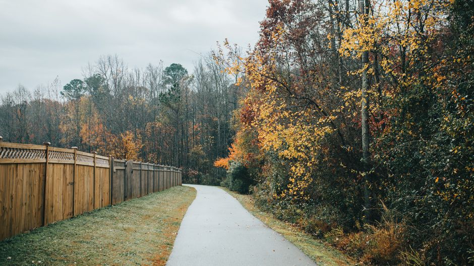
Photo by Ushindi Namegabe via Pexels
The AukCliff Organic Trailblazer Hat in organic cotton has a slightly unstructured crown that makes it comfortable in a way that stiff polyester caps aren't. It provides sun coverage for the face on exposed trail sections and stays on comfortably in wind. The organic cotton breathes better than synthetic in warm weather, and the construction is substantial enough that it holds its shape through regular use rather than collapsing after a few washes.
For people who walk or run urban trails with sun exposure as a real consideration, a hat is genuinely useful sun protection rather than just style. The cumulative UV exposure from daily 30-45 minute outdoor sessions adds up over weeks and months.
Building a Rotation of Urban Trails
The most effective approach to daily urban trail use is having three to five routes of different lengths and characters that you rotate through. A short 20-minute loop for weekday mornings. A 45-60 minute route for longer sessions. A full half-day route for weekends. Knowing these routes well enough to do them without a phone out removes all the friction of getting started.
Seasonal variety within urban trails is more significant than most people expect. The same forest trail looks and feels completely different in late autumn when the canopy is open and the light reaches the ground, versus high summer when it's a tunnel of green. Running or walking a familiar route in different seasons teaches you things about the terrain and the ecosystem that you'd miss otherwise.
Mark your rotation in whatever system you use for scheduling. Treat the 30-minute trail session as a fixed appointment in the same way you'd treat a gym class. The people who sustain daily outdoor time over years are the ones who stopped waiting to feel motivated and started treating the walk as the default, not the exception. Research reviewed by the Community Preventive Services Task Force found a median benefit-to-cost ratio of 3.1 for parks, trails, and greenways, with economic benefits consistently exceeding infrastructure costs, which is the kind of return that explains why cities keep building them.
Frequently Asked Questions
- How do I find trails in my city that aren't on the main hiking apps?
- The best sources are local trail running clubs (social media, Strava groups), city parks department websites, and advocacy organisations like greenway or rail trail groups that operate at the regional level. Many excellent urban trails were built as local parks infrastructure and never received the trail signage or app documentation that recreation-focused trails get. Local knowledge from someone who uses the trails daily is more reliable than any app for finding the good stuff.
- Is it safe to trail run or hike alone in urban parks?
- Urban parks vary enormously in this regard. Large, well-used parks during daylight hours are generally safe. Smaller, isolated green corridors at dawn or dusk carry higher risk. The practical steps are: tell someone your route, keep your phone charged, stay on well-used paths rather than exploring isolated sections alone, and pay attention to who else is using the space. Many urban trail users carry a personal alarm, which is light, cheap, and rarely needed but worth having.
- What's the best way to track urban trails over time?
- Strava and AllTrails both let you log routes and track cumulative distance. Strava's segment system is particularly good at showing you how your fitness changes on a familiar route over weeks. Some people keep a simple log in Notes or a notebook, which doesn't require any technology but gives you a long-term record that apps sometimes lose when you change phones or accounts.
- Can I let my dog off-leash on urban trails?
- This depends entirely on the specific park and its regulations. Many urban parks require dogs on-leash throughout, others have designated off-leash areas, and some allow off-leash on specific trails during certain hours. Check the park's rules before assuming. In practice, off-leash dogs on busy shared trails cause most of the conflict between user groups, and even where it's permitted, a dog that can't reliably recall around wildlife, cyclists, and other dogs should stay on-leash.
- How much elevation gain can urban trails realistically offer?
- More than most people expect. Cities built on varied terrain (Portland, Seattle, San Francisco, Edinburgh, Wellington, Auckland) have urban trails with 300-500m of elevation gain on single routes. Even in flatter cities, trail networks through creek valleys and wooded areas provide enough terrain variation to be genuinely useful for fitness. Flat rail trails and greenways have their own value, especially for recovery days or longer, easier sessions.
Every AukCliff order plants a tree through our partnership with One Tree Planted.


