
The Bibbulmun Track runs 1,003 kilometres from the hills above Perth to the southern port city of Albany, crossing through some of the most biologically rich and visually striking country in Australia. Jarrah and karri forests, coastal heath, granite outcrops, estuaries, and the exposed ridgelines of the Stirling Range are all threaded together by this single continuous trail. It's one of the great long-distance walks in the world and remains less known internationally than it deserves to be.
The track is named after the Bibbulmun people, the traditional custodians of much of the land through which it passes. It follows a route first established in the 1970s, with the current alignment completed in 1998. The Bibbulmun Track Foundation manages the trail in partnership with the WA Department of Biodiversity, Conservation and Attractions.
This guide covers what you need to know.
Track Overview: Kalamunda to Albany
The track starts at the Kalamunda townsite in the Perth Hills, about 25 kilometres east of the CBD, and finishes at the Albany Heritage Park in Albany's town centre. According to the Bibbulmun Track Foundation, the route passes 49 designated campsites spaced at regular intervals along the route, each with a three-sided timber shelter (waugal), tent sites, rainwater tank, and composting toilet.
A full thru-hike takes 50 to 60 days according to Australian Hiker, averaging 20 kilometres per day. The terrain is not extreme in terms of altitude, but the total distance and the nature of the southern section, which crosses exposed coastal heath with limited tree cover, makes physical conditioning and gear selection important considerations. The track passes through eight significant towns, which serve as natural resupply points: Mundaring, Dwellingup, Collie, Balingup, Pemberton, Northcliffe, Walpole, and Denmark before the final push to Albany.
The name waugal refers to the rainbow serpent of Noongar spirituality, a reference that appears throughout the trail's signage and waymarking. The distinctive waugal symbol is painted on trees and posts throughout the route.
Best Sections for Day and Multi-Day Walks
You don't need to commit to a thru-hike to experience the best of the Bibbulmun. Several sections stand out for shorter trips:

Dwellingup to Collie (115km): Through the Hotham Valley and Darling Range, this central section crosses mature jarrah forest with sections that feel genuinely remote despite proximity to agricultural land. The overnight huts here are well-spaced for 2-night and 3-night loops.
Pemberton to Northcliffe (56km): This is the karri country section and the most visually dramatic in the forest zones. Karri trees grow to over 80 metres and the canopy here is unlike anything in the drier northern sections. The Gloucester Tree near Pemberton, a 52-metre fire lookout that visitors can still climb, is worth a detour.
Walpole to Denmark (90km): The final southern section before Albany crosses the Valley of the Giants area with its ancient tingle trees and moves out onto coastal heath and granite headlands above the Southern Ocean. The scale of the tingle trees in the Ancient Empire boardwalk area provides genuine perspective on what old-growth forest means.
The Stirling Range Section: The track skirts the edge of the Stirling Range National Park, and day hikes into the range (Bluff Knoll in particular) work well as side trips from the main track. The Stirlings are floristically the richest national park in Australia, with over 1,500 plant species.
The Campsite System
The 49 designated campsites are the backbone of the trail and what makes planning a Bibbulmun trip tractable. Each camp has the three-sided shelter with sleeping platforms, tent sites on cleared ground, a rainwater tank, and a composting toilet. The shelters hold up to 6 people on the platforms. In busy season the tents-only policy outside the shelter for groups larger than 6 helps manage capacity.
No booking system applies to the designated campsites. First come, first served. This creates a genuine wilderness experience but requires flexible planning, particularly at popular camp spots near trail towns in the busy April to October season. The Bibbulmun Track Foundation's interactive map shows camp distances and facilities clearly.
Water at the rainwater tanks is generally safe but treat it as a supplement, not a primary source. Carry your own capacity and use the tanks to top up. In dry summers the tanks can run low on the southern section, so checking current conditions through the Foundation before setting out on the southern stretch is worthwhile.
Wildlife Along the Track
The southwest of Western Australia is one of the world's biodiversity hotspots. The track crosses through two globally recognised hotspot regions: the Southwest Australian Floristic Region (SWAFR) and the Cape to Cape section of coastal heathland. Wildflower season from August to November in the jarrah and heath zones is a serious draw, with species counts per square kilometre that rival tropical environments.
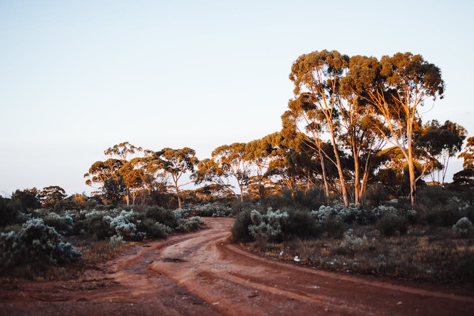
Photo by Rachel Claire via Pexels
Animal sightings vary by section and season. Western grey kangaroos are common throughout the northern sections. The karri forest zone has Western Australia's best chance of wild quokka sightings on the mainland. Echidnas appear frequently on early morning and late afternoon walks. The southern coastal section is good for birdwatching, particularly around the estuaries near Walpole and Denmark.
Snakes are present throughout the route. Tiger snakes and dugites are the species you're most likely to encounter and both warrant respect. They don't seek confrontation, but standing on one by accident is the main risk. Gaiters and watching where you step are the simple mitigations.
Seasons and Conditions
The recommended season for the Bibbulmun is April to November. The Western Australian summer (December to March) brings extreme heat, particularly in the northern sections through the Darling Range. Water sources can be unreliable, fire danger is high, and the exposed southern heath becomes genuinely punishing in full sun with no tree cover.
Winter (June to August) is cool and wet. The forests are lush, the watercourses are running, and the wildflowers start in the southern sections from August. It's also peak mud season on the clay sections of the northern track. Waterproof footwear and a solid rain layer earn their weight in winter.
Spring (September to November) is the optimal window for most walkers. Moderate temperatures, wildflowers in the heath zones, longer days, and the full wildlife activity that comes with the seasonal warming.
Gear and Clothing for WA Conditions
The Bibbulmun is a warm-weather trail for most of its length during the recommended season, but the temperature range across a single day in the Stirlings or on the southern coastal section can span 15 degrees from dawn to mid-afternoon. Layering works better than any single piece of clothing.

Photo by Mitchell Luo via Pexels
For camp and cool mornings, a quality fleece hoodie pulls weight efficiently. The Peak Junkie Hoodie in 9oz premium fleece handles the temperature swing well and doesn't pill after repeated wears, which matters on a 55-day trail. The Born of the North Hoodie from the Origin Collection covers the same brief with different original artwork from artist Maria, hand-drawn and designed in New Zealand.
For active trail hours, the Embrace the Mountain Call Tee in 6.1oz garment-dyed premium cotton is the kind of trail tee that survives a long trip without looking or smelling wrecked. The same applies to the Life on the Edge T-Shirt. Both are pre-shrunk and colourfast, which matters when you're washing in town sinks every four to five days.
Footwear on the Bibbulmun requires some thought. The sandy sections of the southern coastal heath suit a lower, lighter boot. The clay and root sections of the northern jarrah forest after rain suit something with ankle support and good mud shedding. Many thru-hikers carry two pairs and swap between sections.
Resupply Points and the End-to-Ender Programme
The eight towns along the route serve as natural resupply points. Dwellingup, Pemberton, and Walpole have the best facilities in terms of grocery stores and accommodation. Northcliffe is smaller but has a community resource centre that actively supports track walkers with a small store and accommodation options. Most towns have a post office where walkers send resupply boxes ahead.
The End-to-Ender programme is officially registered through Trails WA and the Bibbulmun Track Foundation. Walkers who complete the full distance can register their achievement, receive a certificate, and join the End-to-Ender community. The programme requires completing the track as a continuous single thru-hike (section-hiking over multiple visits doesn't qualify for End-to-Ender status but is still fully valid as a way to experience the track).
The Foundation's website and the Bibbulmun Track app (downloadable offline) are the primary planning resources. The Foundation also publishes a series of section maps that are worth carrying in physical form as a backup.
FAQ
How long does it take to hike the full Bibbulmun Track?
Most thru-hikers complete it in 50 to 60 days, averaging around 18 to 20 kilometres per day. Fitter walkers have done it in 40 days. Budget at least 55 days if this is your first major long-distance walk. Factor in zero days in towns for resupply, rest, and weather delays, particularly in the southern section.
Is the Bibbulmun Track difficult?
It's a sustained distance challenge rather than a technical one. Elevation gain is modest by mountain trail standards. The difficulty comes from cumulative distance, managing water between sources, and the mental demands of a 50-day walk. A solid base of regular hiking (30km+ weekend walks) is good preparation.
Do I need to book campsites in advance?
No. The 49 designated campsites are first come, first served. No booking system applies. In peak season (September to November) popular sites near trail towns fill early. Having flexibility in your daily distance targets helps manage this. The Foundation's online camp log shows recent usage which can guide planning.
What wildlife should I be aware of on the Bibbulmun Track?
Snakes are the main hazard to be aware of. Tiger snakes and dugites are venomous and both present throughout the route. Watch where you step, particularly in warm weather when snakes are active. Gaiters provide meaningful protection. Kangaroos, echidnas, quokkas (in karri country), and a wide range of birdlife are the rewards.
What is the best single section of the Bibbulmun Track for a first visit?
The Pemberton to Northcliffe section through the karri forest is the most visually striking section for a first visit. The Walpole to Denmark coastal section is the most dramatic for landscape variety. Both are accessible as multi-day walks with reasonable public transport connections at either end.


